
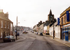
Architecturally, Whithorn, with its two-storeyed town houses and wide main street, comes as something of a surprise, after the visitor has passed through the traditional strip villages of Sorbie and Kirkinner, and through the countryside dotted with single cottages and groups of farm buildings. The underlying explanation for this more urban feel is that you are indeed now entering a town: Whithorn, like Wigtown, is a Royal Burgh and has traditionally been a capital for the South Machars.
While the existing houses date predominantly from the period of the Napoleonic Wars and first quarter of the nineteenth century, when there was significant rebuilding and when the town probably came to look much as it does now, an aerial view shows that these eighteenth century and nineteenth century buildings have been set along a street which respects a much older pattern : traditional long narrow burgage plots which extend behind the houses, and the narrow enclosures at either end of George Street belong to the Middle Ages, the period of Whithorn’s greatest prosperity and expansion. The visitor still has a sense of enclosure in the centre of George Street, looking south to the cross-house at the crest of the hill, and north to the narrowest point where George Street joins St. John Street. This safe enclosed space would have been the place where cattle and sheep could have been kept in folds, where cattle trading, markets and fairs would have taken place. These were authorised by the burgh’s Royal Charter and continued into the nineteenth century, with diminishing importance as the system of royal burghs began to lose its monopoly on trade.
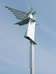
 The focal point of Whithorn at the time when most of its houses were built would have been the tolbooth and gaol, now removed from the widest point of the street, at approximately the site of the War memorial. According to early travellers, there were also a series of “luckenbooths” for traders in the widest part of the street, which now provides extra parking spaces. Weights and measures were also checked by the burgh, and burgh privileges to trade were jealously guarded ; Wigtown and Whithorn were frequently in dispute about dues payable and the destinations of profitable cargoes. Without knowing the history of this part of the town, one might well agree with the eighteenth century minister, Christopher Nicholson, who commented that the town was “inconveniently narrow at both extremities and uselessly wide in the middle”. The town house was removed from the centre of George Street in 1814 And rebuilt on the west side, where its square tower and attractive circular spire can be seen, projecting beyond the roofs of the houses. Until local government reform in 1974, this continued to be the site of town council meetings and municipal government.
George Street, now designated an Outstanding Conservation Area, presents a mixture of relatively sophisticated town houses with single storey cottages in the vernacular Scottish tradition. Number 29 is a good example of a town residence, with circular-headed doorway, cornice and parapet with central panel. Others show by their steep roof pitches that they hark back to an earlier era, when they were thatched, and have small irregularly spaced windows, which seem to belong to the seventeenth century rather than the Georgian period. The ¾ mile-long terrace of houses in George Street is almost complete, appearing just as it must have been developed in the early nineteenth century, with two exceptions : the Catholic Church, St. Martin’s and St. Ninian’s, was built on a gap site in the 1950’s and the site at no. 61-3 George Street, which was burnt by fire in the 1930’s, but rebuilt to the pre-existing building line.
By local tradition, the houses in Whithorn are generally painted in bright colours, with contrasting tones used for the walls and for the facings and courses, allowing textures and detailing to stand out, and for the buildings to be emphasised strongly, “coming forward” to the building line in cases where strong tones have been chosen.
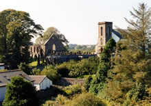 Whithorn’s chief historical treasure, however, can only be glimpsed from George Street : the mediaeval Priory, archaeological site and Museum of Christian stones are hidden from view, and the early Christian (Fifth century) heart of Whithorn was probably sited on the gentle rise at the top of Bruce Street. The entrance to the Priory, however, constitutes one of Whithorn’s most pleasing groups of buildings and provides a taste of the grandeur of what once lay behind it. Framing the entrance to Bruce Street, “The Pend”, a late mediaeval arch flanked by pillars with moulded caps and grandly surmounted by the Royal Arms of Scotland, tempts one off the main street towards the original site of St. Ninian’s shrine A “Pend” in Scotland is used to refer to any passageway driven through a building, so creating a suspended room above it, but, notably, other monastic gateways in Scotland are also referred to as “Pends”, such as that at St. Andrews. The Pend building probably once stood much taller, and possibly had the form of a tower, familiar in monastery gateways elsewhere : the coat of arms on such an imposing building would have served as an advertisement of the power of Whithorn’s Prior, who was under royal protection and had an all but regal power within his domain (known, in fact, as a “Regality”). The heraldic panel is likely to date from about 1500 and is one of only four Stuart coats of arms of this quality in Scotland; the Bishops’ arms on the caps of the pillars are those of Bishop Vaus (Vaux, Vans), who was bishop from 1482-1508. On the southernmost pillar, there are the arms of Vaus , surmounted by a crozier, and on the northern pillar, the arms of Vaus quartered with the arms of Shaw (three closed cups argent on a ground azure) surmounted by a Bishop’s mitre and mantled with a cope.
 Pilgrimage at Whithorn
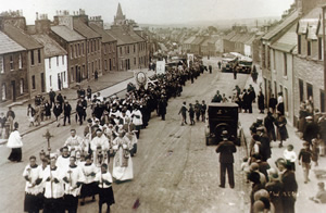
Even today, passing under the gatehouse, one has the sense of leaving one world and penetrating into another : in the days of pilgrimage, one was indeed passing into the sacred world of the monastery, with its own order, calendar and organisation. Archaeology has shown that Bruce Street respects the line of a road with a 1500 year old history and we know that at least five monarchs of Scotland came on pilgrimage by this route. Facing Bruce Street, in fact, on the eastern side of George Street, is King’s Road, which originally led from the landing place at the Isle of Whithorn across country to St. Ninian’s shrine.
Further up Bruce Street , facing the archaeological site, is the museum, (The Whithorn Trust) containing one of the most important collection of carved and inscribed Christian stones in Scotland. The stone forming the lintel to the door, which is dated 1730, was actually taken down from a small school building, which once stood nearly opposite the museum and which was excavated during the 1980’s. The stones were first gathered together from various sites by the Third Marquess of Bute, one of the great patrons of Christian archaeology, and the man who financed excavations at Whithorn in the last decade of the nineteenth century. The current appearance of the graveyard and crypts owes much to his reconstruction. The view from the balcony over the crypts gives one an unexpected view of George Street from behind : the narrow gardens, unexpected extensions, the Ket Burn, the tower of the Old Town Hall, all present a pleasing jumble from this vantage point over the town.
 The parish church was built in 1822, and the Manse, now a private house, in 1819, when the heritors of the parish decided to replace the old church, which had occupied the former nave of the mediaeval cathedral since the Reformation. The severe nineteenth century church was built over remains of one of the mediaeval transepts; later the tower was added to the front. Within feet of each other, the early Christian, the mediaeval, the post-Reformation and the modern jostle for space on this small hillock.
Whithorn participated to the full in the complex church schisms of the Scottish Protestant Church. Apart from the Established Church, which remained at its current hilltop site, there were also the Reformed Presbyterians, who built first at the site now occupied by St. John’s Garage in St. Johns Street. There was also a Free Church in King’s Road, at the site of the modern Council flats and parking lot, and a Cameronian meeting house in Drill Hall Lane, which briefly possessed its own ministers and a thriving congregation. In addition to these four, particularly with the increase of Irish immigration from the early nineteenth century, a Catholic church was established, at first beyond burgh boundaries at a tin structure on High Mains Farm (then owned by the 3rd Marquess of Bute) , and then eventually in the centre of George Street.
